生成中...【新闻趣摘】
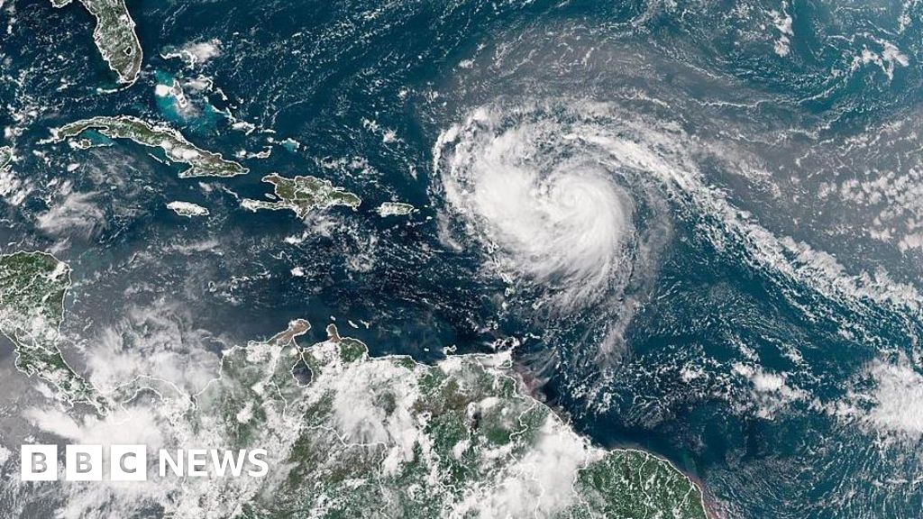
"飓风艾琳"正在加勒比海上演"变形记"!这个周末刚创下160英里/小时风速的"五级大佬",虽然现在降级成了三级"小可爱",但气象专家警告它正在"膨胀发育"——风暴半径已经扩展到205英里,活像个在海上吹气球的孩子。最惨的是美属维尔京群岛和波多黎各,不仅要面对15厘米的暴雨,还得提防能把人"嗖"一下卷走的离岸流。美国海岸警卫队已经紧急叫停了圣托马斯等港口的船只进出,而佛罗里达的冲浪爱好者们可能要失望了——这次带来的可不是理想浪花,而是"要命"的巨浪。看来今年大西洋飓风季的开幕秀,艾琳是要把"我不是针对谁,我是说在座的各位都要小心"写在脸上了!
---
**Hurricane Erin grows in size as it barrels towards Caribbean**
飓风艾琳规模扩大 直扑加勒比地区
**Hurricane Erin is expected to intensify, despite being downgraded to a category three storm as it moves towards the Bahamian Archipelago in the Caribbean.**
尽管降级为三级飓风,飓风艾琳在向加勒比巴哈马群岛移动时预计将增强。
**The storm became a rare category five cyclone on Saturday night, with winds up to 160mph (260km/h), but meteorologists expect it to grow in size as it develops over the next few days.**
该风暴周六晚间曾增强为罕见的五级飓风,风速达160英里/小时(260公里/小时),但气象学家预计未来几天其规模将扩大。
**The US National Hurricane Center (NHC) says Erin is forecast to have tropical-storm-strength winds extending 205 miles from its centre.**
美国国家飓风中心表示,预计艾琳的热带风暴级风力将从中心向外延伸205英里。
**Storm-related hazards, including flash flooding and landslides, are expected in the Virgin Islands and Puerto Rico.**
美属维尔京群岛和波多黎各预计将面临暴风雨引发的危险,包括山洪暴发和山体滑坡。
**The first hurricane of the 2025 Atlantic season, it is not forecast to make landfall over the mainland US.**
作为2025年大西洋飓风季的第一个飓风,预计它不会在美国大陆登陆。
**Erin underwent rapid intensification as it barrelled towards the Caribbean on Saturday, with NHC director Mike Brennan telling a briefing that it had"explosively deepened and intensified" after growing from tropical storm strength on Friday.**
周六,艾琳在向加勒比地区移动时迅速增强,美国国家飓风中心主任迈克·布伦南在简报会上表示,它从周五的热带风暴强度"爆发性加深和增强"。
**But its windspeeds - along with its forward movement - slowed as it began to turn northwards away from the Caribbean.**
但随着它开始向北转向远离加勒比地区,其风速和前进速度都减慢了。
**The NHC expects it to continue to turn away from the US over the course of next week and back into the Atlantic.**
美国国家飓风中心预计,它将在下周继续转向远离美国,回到大西洋。
**The hurricane is currently passing north of Puerto Rico and the Dominican Republic with winds up to 125mph.**
飓风目前正以高达125英里/小时的风速经过波多黎各和多米尼加共和国北部。
**Rainfall totals across the Virgin Islands and Turks and Caicos islands are predicted to reach 6in (15cm) on Sunday.**
预计周日美属维尔京群岛和特克斯和凯科斯群岛的降雨总量将达到6英寸(15厘米)。
**Tropical storm warnings are in place for the Turks and Caicos islands, where strong winds and rip currents - which can rapidly drag people out to sea - are anticipated.**
特克斯和凯科斯群岛已发布热带风暴警告,预计将出现强风和离岸流——可能迅速将人卷入海中。
**The NHC said Erin was expanding, with hurricane-force winds extending up to 25 miles from its centre as of 09:00 GMT.**
美国国家飓风中心表示,截至格林尼治时间09:00,艾琳正在扩大,飓风级风力从中心向外延伸25英里。
**The storm will generate life-threatening surf swells and rip currents up almost the entire US east coast, said Mr Brennan.**
布伦南表示,风暴将在几乎整个美国东海岸产生危及生命的巨浪和离岸流。
**Florida and mid-Atlantic states will see the most dangerous surf conditions, he said.**
他说,佛罗里达州和大西洋中部各州将面临最危险的海浪条件。
**Bermuda could also see"life-threatening" surf conditions and heavy rainfall, Mr Brennan added, as well as the Bahamas.**
布伦南补充说,百慕大和巴哈马也可能出现"危及生命"的海浪条件和强降雨。
**Because of gale force winds, the US Coast Guard is imposing restrictions on vessels at ports on St Thomas and St John in the US Virgin Islands, as well as six municipalities in Puerto Rico, including San Juan.**
由于大风,美国海岸警卫队正在对美属维尔京群岛圣托马斯和圣约翰港口以及波多黎各包括圣胡安在内的六个城市的船只实施限制。
**The National Oceanic and Atmospheric Administration (Noaa), the US government's primary weather agency, has predicted an"above normal" Atlantic hurricane season this year.**
美国政府主要气象机构国家海洋和大气管理局预测,今年大西洋飓风季将"高于正常水平"。
**The number of tropical storms that reach category four and five is projected to increase due to global warming.**
由于全球变暖,预计达到四级和五级的热带风暴数量将增加。